Showing posts with label Walkable Community. Show all posts

Tuesday, April 24, 2012

Potomac Yard Metro opponents cite GW Parkway purity

Officials have refined the options for where to place the Potomac Yard Metro station. Neighbors concerned about impacts to the George Washington Parkway are opposing 2 options which place the station closer to planned development, but the Metro station will bring far more long-term traffic relief than just avoiding temporary construction.

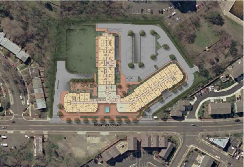
Alternatives for the Potomac Yard Metro station.
The project is now in the middle of its Environmental Impact Statement (EIS) phase. Officials have refined a set of 9 alternatives down to 3, plus a 4th no-build scenario. The City of Alexandria is now required by law to evaluate each of the 3 alternatives that made it through the screening phase.

Some residents at a public meeting on April 19 vehemently opposed alternatives B and D, because the project's construction could temporarily affect the George Washington Memorial Parkway. Both of those alternatives place the station farther north than the other alternative, A.

The speakers came primarily from Potomac Greens and Old Town. Some were fine with a station at A, while others opposed the station entirely. For most, the Parkway was the primary reason they cited, though some also feared construction noise and didn't want a station near their homes.

Impact on the GW Parkway

Those opposed to alternatives B and D repeatedly lauded the uniqueness of the parkway among capital cities worldwide. They demanded that officials throw out any build alternative that interferes with the roadway, even for two years or less.

Alternative D, located closest to existing and planned density in the area, probably has the most impact on the GW Parkway. This alternative requires elevating tracks to cross over the existing Metrorail and CSX tracks, passing through an aerial station roughly where the movie theater now stands, and then passing back over the CSX tracks to rejoin existing tracks.

There are construction benefits and drawbacks for this option, but it undoubtedly puts the infill station much closer to existing neighborhoods and the densest portion of future planned development.

Portion of Alternative D station and track (click through for full proposed construction zone)

At least two speakers at the meeting asked for a traffic study, but this study has already been done as part of the Potomac Yard small area plan (chapter 6). One infill Metro station isn't a traffic panacea, but according to the study, traffic will be worse in the Potomac Yards area if the station is not built.

The Potomac Yard small area plan calls for drastically-reduced density without a Metro station. But even in this scenario, traffic will be worse than with higher density and a Metro station. The closer the Metro station is to existing and planned density, the more cars it will take off the road.

Nonetheless, Old Town resident Poul Hertel reached as far back as 1902 to protest impacts on the Parkway, quoting a document from the McKinley Commission referring to the "Mount Vernon Road" as "affording an opportunity for the most refreshing and delightful drive to be had in any direction from Washington and not to be equaled at any great capital of the world."

While historical context is important, the massive back-ups on this main artery into the city mean McKinley's commission surely would have enjoyed the "refreshing and delightful" drive far less today. They probably would have made a temporary trade-off in parkway accessibility to save green space farther out from the city and temper traffic increases long-term.

The EIS process

Alexandria staff explained at the meeting that they are working with the National Park Service, and nothing will go forward without approval by the NPS. There are also other requirements regarding technical and financial viability, among other things.

Officials cannot throw out alternatives during the EIS phase until the city puts forward a locally-preferred alternative. But speakers demanding staff eliminate parkway-disturbing options did not yield, as speaker after speaker stood up to call for the city to change course in a way that is not possible.

David Fromm of Del Ray pointed out that the city could have done a better job explaining the reasons the screening process put forward each alternative. He was right, but it didn't appear that the most vocal in the audience would have been convinced by any option that breached the sanctity of the GW Parkway, regardless of long-term traffic benefits.

City staff periodically referred speakers to the PY website since they could not cover the vast amount of information about the potential development in a single public meeting.

Density, transit and the urban core

One speaker seemed to understand the larger point. Though she is a Potomac Greens resident who surely will be impacted by the construction, she pointed out that without the infill station, future growth in the area will make it so everyone will have plenty of time to admire things along the GW Parkway-turned-parking-lot, as traffic continues to get worse.

Large growth in the DC area is coming, so area municipalities need to responsibly manage that growth with improved infrastructure. Her statement brought sporadic applause, indicating she was not the lone supporter of the station.

For tangible proof of the traffic-reducing impacts of public transit and responsible land use planning, look no further than the Rosslyn-Ballston-Clarendon corridor. In this corridor, with access to public transit, people choose to live closer to jobs, stores, restaurants, etc.

In turn, people use their cars less, if they keep a car at all. This is why traffic volumes in that corridor have stayed relatively flat over the past 30 years despite massive development. Creating these livable communities reduces driving and therefore traffic.

With growth coming to the DC area, we can either clear-cut and pave over more outlying forests, or add more density close to the core. The most responsible action is to create dense, livable communities with good access to multi-modal transportation.

Even if urban living isn't for everyone, real estate pricing and trends indicate there's ashortage of walkable, transit-oriented communities and an over-supply of distant, exurban sprawl.

To be good stewards of our region, we simply must build density near transit near the urban core. If the most feasible option requires disturbing the GW Parkway during construction, that should not be a reason to avoid it. Temporarily interfering with GW Parkway traffic patterns does not outweigh losing acres of land that would have to be built farther out to replace the lost units and transportation capacity in Alexandria.

Audio of the April 19 public meeting is available here, and the presentation itself is available here and embedded below.


Cross-posted to GreaterGreaterWashington

Sunday, December 04, 2011

Arlandria: When A Plan Comes Together

With all eyes either gazing in adoration or glazing over in rage at the waterfront plan, a small, community-spurred plan to bring about changes in a struggling, but hopeful neighborhood has finally come to fruition.

The Long Road

The Vision from the 1998 Plan.
The Arlandria community has been planning for change longer than any other neighborhood in Alexandria. We are now a decade into implementation of the Arlandria Revitalization Plan, the result of the City and community-supported 5-year planning effort from 1998 to 2003. Broadly stated, the goal of the Plan was to build on the strength of Arlandria as a pedestrian-oriented, mixed-use place through the redevelopment of underutilized sites. Re-development of the "oppurtunity sites" was the anticipated catalyst for the proposed revitalization.

Absent that outside investment, the City pursued modest improvements, but the opportunity to make a significant impact in a densely poor community was limited. Resources were put into an interim marketing strategy to strengthen existing businesses and community members worked to establish facade improvement guidelines for individual storefronts. But the efforts proved to be futile since many shopowners were barely breaking even. In the decade since the plan, shops were closing and turning over at an increasingly alarming rate. The shopowners that remained were barely holding on.

Redevelopment proposal compared to Arlandria Plan illustration
A 2008 follow-up feasibility study, publicly unveiled 3 years ago, ultimately confirmed that conditions in Arlandria made development unfeasible. Paraphrased, "Arlandria was not worth the investment." The study pointed to an on-going perception of crime, a poor built environment, and lack of economic diversity as the three major impediments to economic development.

Grass-Roots Community For All

The City attributed the stagnant plan implementation to a lack of community involvement. That comment and the implication of the feasibility study became the catalyst for the community led, city-supported grassroots efforts that followed. Within the parameters of maintaining the ethnic and economic diversity that define Arlandria, achieving sustainability became the overarching goal. Without outside investment, a group of volunteers took on the challenge of what remains a higher standard of fostering a supportive environment. Working hand-in-hand with neighbors and social service providers, community residents created a small business incubator in the farmers and artisans market. The Four Mile Run Farmers and Artisans Market is the sole market - in both Alexandria and Northern Virginia - to welcome SNAP (food stamps), a labor of love which took market organizers countless extra hours to establish and staff weekly. And the community has banded together to improve streetscapes and parks and maintained a presence at service provider and quality of life meetings to ensure every resident and visitor feels safe in our community.

Along with the City, the neighborhood paved the way by working with our Community Oriented Police (COPS), ARHA, Community Lodgings, Wesley Housing, the Community Services Board, the Chirilagua Coop and most recently Arlington Housing Corporation to preserve existing housing and conditions for the city's most vulnerable citizens, and have strongly supported the inclusion of workforce housing to create upward mobility for hard-working residents - who would otherwise have to leave the City to improve their circumstance. According to Census, Arlandria's population is still highly transient (30% turnover per year, 90% every 5 years). The city and grassroots organizations have aimed to create an environment that allows more residents to make Alexandria into a long-term home by providing a wide range of housing. That solution requires something more than very low rent and very high cost properties. Economic diversity and livability are key to a sustainable community.

Finally...

The long-awaited plan to re-develop the Arlandria Shopping Center (Mount Vernon Village Center) overcomes the challenges presented in the feasibility study from 3 years ago. After years of painstaking, frustrating and sometimes seemingly futile efforts, one of our community partners has proposed the first step towards fulfillment of a decade-old promise to realize Arlandria as the proud waterside gateway into our wonderful city. In a constrained-resource environment, Arlandria Center, LLC has created a design that addresses the key issues in our neighborhood. It leads the way by making a positive change to the built environment and addresses the perception of crime by adding eyes on the street - where increased vitality becomes a deterrent to crime.

This current development application addresses many of the design goals of the Arlandria plan, proposing a mixed used property consisting of two multi-family residential buildings that maintain the 50,000 sq. ft. of retail along Mt Vernon Avenue (maintaining approximately the same amount of retail). Parking would be underground or buried within the building at grade. The plan includes streetscape improvements to Mt Vernon Avenue and Bruce Street, which include street trees, new bus shelters, and sidewalk widening. The high quality, contemporary design is in compliance with new green building standards and incorporates new affordable housing units for households earning less than 60% of the Area Median Income. The property also improves access to and increases visibility of Four Mile Run Park.

The Mt. Vernon Village Center proposal for 450+ housing units is a first step on a long road to alleviate an impending housing crunch. The median age of housing stock within one mile of the project is 55 years old; within 5 miles: 44 years old.

The development would also provide the city-code required 940 underground parking spaces. The project remains open to utilizing some parking spaces for other subsequent developments if the opportunity presents itself.

And the proposal includes a phased approach, retaining as much existing retail as possible during construction. MOM's and CVS, for instance, could continue to operate if they choose on the northern portion of site while the southern portion is built.

Community Benefits

The plan fulfills the Arlandria Plan requirement for 10-15% open space: 10% of the property space would be reserved for public open space and another 5% would be for resident use. The building would be set back back 40 feet from Mt Vernon Avenue for pedestrian plaza space and will be pulled back 5 additional feet on Bruce Street to create better access to Four Mile Run Park and better vehicular access to stores and residences. The project would also fund up to $200,000 for new tennis/basketball courts, which would be relocated per the 4MR Park master plan. 7,000 square feet of the property along the park would be reserved for a pedestrian promenade with the potential for a future road should the City desire at some point. The development would also improve the quantity and quality of stormwater runoff from the site.

The primary entrance to the residential portion of the parking garage would be through the center courtyard aligned across from Russell Road and the developer would rebuild that intersection and the southern entrance to the property for better automobile access than exists today.

The development conforms to all of the standards set out in terms of bulk, set back and open space, but needs to be 7 additional feet taller in the center of the building to achieve the scale need to accommodate 28 units of affordable housing throughout the property. This housing which would be open to holders of housing vouchers and others who make less than 60% of Area Median Income.

The residential portion of the property would be built to LEED green building standards, and the commercial portion would be build to LEED Silver standards.

The project also includes $51,000+ in today's dollars (adjusted for inflation) annually for transportation management to keep single occupancy vehicle trips from the development to less than 40% of total trips. To help accomplish that, the developer would additionally install new bus shelters with real-time bus arrival data and would also install on-site bicycle amenities, including a Capital Bikeshare station. The developer would also provide a 20% employee transit subsidy. In the future, the development would be required to partner with other property owners to create a Transportation Management District to make further improvements to transit.

A little mentioned project attribute is that it also meets the design guidelines from the Four Mile Run Restoration Plan. This plan was created by the community over several years as joint effort between the City and Arlington County working through the Northern Virginia Regional Commission. See examples of suggested architecture and building massing in the following excerpts:

Challenges and Opportunities

"Neighborhoods that mix land uses, make walking safe and convenient, and are near other development allow residents and workers to drive significantly less if they choose. In fact, research has found that in the most centrally located, well-designed neighborhoods, residents drive as little as half as much as residents of outlying areas. Along with these benefits, mixed-use development can improve communities in other important ways, including supporting affordable housing by lowering transportation costs. Studies have also shown that mixed-use development, especially in concert with other smart growth strategies, provides significantly higher returns to local governments through property and sales taxes while requiring lower per unit infrastructure and public-service costs." (EPA)

The majority of road issues in our area are rush hour bottlenecks further on down the line, such as where West Glebe and South Glebe come together and where those roads hit Route 1. There is the need for targeted solutions for those bottleneck areas as well as better transit and bike options to allow people to switch modes away from single occupancy vehicle driving. Mt. Vernon Avenue in Arlandria is not a highway, nor even a high capacity road. At its best, it could be an urban boulevard with wide sidewalks, easy pedestrian crossing places, and slow moving traffic. The Arlandria Plan vision of pedestrian-oriented, transit-oriented development is the antidote to the bottlenecks problems created by sprawl induced cut-through traffic. 

Post rush hour traffic on Mt Vernon Avenue
9:15 on a Friday morning.

The small area plan is about making a pedestrian friendly community that brings current and future residents out on foot to enjoy the neighborhood. Right now, we are bathed in a sea of empty parking lots and people-second design. Bus routes connect the Avenue to points south and north, the Metro stations and the Pentagon. "Circulator" routes from a future Potomac Yard Metro and to the future transit line along Route 1 are in the works, but this will only work if complimented with sufficient density.

In order to maintain our diversity, we have made a conscious decision that we would prefer to add the density of economic diversity that mitigates the negative impact of being the most impoverished community in the city. The development proposed by the Mt. Vernon Village Center helps us realize our long-awaited goal of becoming a safe, walkable, sustainable and inclusive community. We are proud of our multicultural environment, we have immigrants from around the world, but without the proposed development, the opportunity to fulfill Arlandria's potential will likely slip by and drive our neighborhood back to it's 'unfeasable' state. What we have learned through our journey is that every resident has a stake in making their own neighborhood the best it can be. All of us have a responsibility to step forward with an investment of the time it takes at least pay attention to the opportunities presented in their area. Whether it's the city or a developer considering making a change, make your voice heard. We feel strongly that this is the best opportunity to make Arlandria one of the City's greatest success stories. If you believe that too, now is the time to step forward, write a letter, show up, or even join in. Everyone's welcome - it's Arlandria!
___________________________________________
Submitted by Kevin Beekman, Melissa Garcia and Nick Partee

Wednesday, October 26, 2011

New Potomac Yard Metro Alternative West of CSX Tracks

Intial Alternatives Considered
(EIS Screening of Alternatives Presentation)
The hope of a Potomac Yard Metro station on the west side of the CSX tracks is still alive.

More importantly, during the City's scoping phase of the Environmental Impact Statement preparation, Alternative D3 was introduced and kept on the table. This is important, because options on the west side (the Route 1 side) of the CSX tracks move the metro closer to more potential riders and will therefore increase potential ridership. If you've followed the PY Metro news closely, you'll recall that the 'D' series of alternatives are aerial station options that require the tracks to elevate, cross over to the west side of the the CSX tracks, then return to the east side to rejoin the existing tracks. (Read more about PY Metro here and here. Also, see the official site.)

The aerial alternatives had all been deemed prohibitively expensive and/or technical infeasible. But during the scoping phase of the EIS, the new D3 alignment for an aerial station within the PY development footprint proved a contender. It is listed in the EIS Initial Screening of Alternatives as: "Consistent with purpose and need, consistent with land use and development plans, technically feasible, [and] financially feasible." In fact, all five remaining options meet these four criteria.

The Arlandrian has previously reported the PY Metro Advisory Group's findings that show the 'D' (aerial station) and 'C' (underground station) series of alternatives significantly increase the amount of potential development, and therefore people, within the 1/4 mile and 1/2 mile walkshed. They move the station further into the eventual PY development area, and also closer to the medium density neighborhoods to the west. These neighborhoods include Arlandria, Del Ray, Lynhaven, etc. Alternative 'A' would serve significantly fewer people without a lengthy walk, which will drive some away from Metro as a feasible transportation option. The new D3 option is close to options B1, B2, and B3, but if it is on the west side of the CSX tracks, it saves a lot of walking and one set of steps (you'd have to go up, over, and down to get to any alternative to the east of the CSX tracks). Options D1 and D2, which did not make the cut, were further north and so would have served the planned densest part of the yard even more conveniently, but did not prove technically feasible. Review the report for more information about feasibility.

The underground station alternatives proved to be extremely expensive, and based on the EIS scoping document, not technically feasible. The proximity to Four Mile Run and the CSX tracks appears to be to blame. With option D3 on the table, the PY Metro station could serve almost as many people as the underground and alternate aerial options for a much smaller cost.

Other new alternatives that were considered during the scoping session and found incompatible with stated goals were a VRE station, parking garages, and additional stations developed in other parts of Alexandria. When a final alternative is chosen, it will be compared with the no-build scenario. At that point, the PY Metro Station Implementation Work Group will send the EIS forward to WMATA. The public has opportunities for input throughout. See the high level project schedule below (with projected station opening in 2016).
Potomac Yard Project Schedule (EIS Screening of Alternatives Presentation
This decision on which alternative to choose is far from made. One of the reasons the 'D' series of alternatives was rejected earlier was the developer didn't want to deal with building out the PY development while working around Metro construction. This is still a possible concern, though perhaps the new alignment was devised to mitigate this impact. It is also possible that option D3 is still more expensive than option 'A' and the various 'B' options. More information should be available tonight.

There is a public meeting tonight to review the Initial Screening of Alternatives at 6:30pm in the City Hall, Council Work Room, 301 King St.. Please attend if possible and lend your support for option D3.

Thursday, June 02, 2011

Local Planner Discusses Arlandria Planning and Implementation

Brandi fields questions
Since 2009, the Arlandria Action Plan Advisory Group has been helping guide implementation of the 2003 Action Plan (large PDF).  One of the leaders of the effort on the City staff side has been City Planning and Zoning Urban Planner Brandi Collins.  Last week, she was invited to speak at a Coalition for Smarter Growth event with a couple of other young planners at their "Young Planner Showcase".  The event was held at the National Capital Planning Commission.

Here are her slides (PDF), which are displayed during the video.  See below for the video of her presentation, or use this link to view on YouTube if the embedded video isn't working for you.  Brandi's section starts at about the 06:20 mark and runs about 20-25 minutes, including a Q and A session.  She does a great job promoting what we're doing as a community, and we are appreciative of the efforts so far.  Keep up the focus and great work on Arlandria!


Friday, January 28, 2011

All aboard at Potomac Yard Metro Station... in 2016

The Potomac Yard infill station in Alexandria is on track to open in 2016. It had better, because any delays could imperil Alexandria's funding for the project.

An Environmental Impact Statement (EIS) is now underway, as required by law. As governments commonly do with EISes, they have launched a project website to disseminate information to the public.

The EIS process should last through 2013, and the city is closely managing the project against a goal of opening by the end of 2016. Vice Mayor Kerry Donley emphatically reminded staff at a meeting Tuesday that funding for the new Potomac Yard station is dependent upon on-time completion:
Any slippage in time along the way costs more money in one of two ways. Either in expense or inability to gather revenue as quickly as we would like... all of our projections on bonds, all of our projections on repayment of the bond are all predicated on opening in 2016.
The City of Alexandria created a special tax district and tax increment financing (TIF) area to pay for the station. That revenue depends on development around the station, but the development depends on the station. The city has issued bonds to pay for the station and budgeted funds to cover the bond debt service the first few years, but is counting on the TIF for later years. If the station and surrounding development are delayed, the bond repayment costs could cut into other city services or cause other financial complications.

To allay fears, staff informed Council that the City has hired a project manager to keep it on task. Also, WMATA is partially responsible for project oversight, and John Thomas, the project manager for the New York Avenue infill station, is overseeing the station for WMATA.

The EIS process will include refining the Metro station location alternatives. All alternatives are on the table, including not building the station, our preferred option that would better benefit existing neighborhoods, and any other alternatives they might think of during the process. All station configurations — above ground, below ground, center platform, side platform, etc. — are also on the table.

There are two meetings coming up to inform the public about the EIS and the scope of the alternatives, the afternoon and evening of Feburary 10 at Cora Kelly Rec Center in Arlandria, 25 West Reed Ave, Alexandria.

To watch video of the PY Metro presentation from Tuesday's City Council Meeting, click here and go to docket item 21 (this will take you to 49:45 on the video). Presentation and discussion runs about 18 minutes.

(cross-posted to GreaterGreaterWashington)

Saturday, October 16, 2010

4MRMarket Report: "More Than Just a Novelty" Edition


When we began planning the 4MRMarket back in May with the hope of opening in little more than a month, we had no idea whether we'd make back the money we invested, let alone make it through the season.  Now, as we wind down this year's market in the final few weeks, we are happy with what we've accomplished, but eager to build and grow and provide more opportunities fulfill our mission statement:
"bring fresh, nutritious food to people of all income levels, provide an opportunity for local artisans and producers of goods to bring their wares to market, strive to reflect the diversity of the community, and improve the quality of life for Arlandria residents and visitors, as part of an overall vision to expand and improve Four Mile Run park and the surrounding neighborhood".
Next week, October 24th, our penultimate market of the season, will be the 4MRMarket Harvest Party complete with music games and live performances.  Stay tuned for details shortly.

This week, the Four Mile Run Farmers & Artisans Market still always has plenty to offer folks, whether they walk, drive or come on a bicycle, but this week we spotlight the many folks who come to market using our great system of nearby trails and bike lanes. VƩloCity returns to the 4MRMarket this Sunday with their mobile bike repair shop.

Biking in with VĆ©loCity, entertainer Aaron Lee will be providing music in the market lounge.  Aaron is a ukulele songwriter on a all-bicycle-powered concert tour. About a month ago he played at VĆ©loCity in Old Town, and he will be back in the area tomorrow (Sunday, Oct. 17) at 4MRMarket. One goal of his tour is to promote local community organizations, like the Four Mile Run Market and bike co-op.

This 4MRide event is again another oppurtunity to educate citizens in understanding the importance of sharing the road responsibly and with respect and encouraging folks to try out our amazing park trails. So get on your bike and come on out.


_______________

The Four Mile Run Farmers and Artisans Market (Alexandria, Virginia 22305) brings fresh, nutritious food to people of all income levels, provide an opportunity for local artisans and producers of goods to bring their wares to market, strive to reflect the diversity of the community, and improve the quality of life for Arlandria residents and visitors. It is part of an overall vision to expand and improve Four Mile Run park and the surrounding neighborhood.

4MRMarket is open every Sunday from 8am until 1pm from April through October in Four Mile Run Park at 4109 Mt Vernon Avenue, Alexandria.

For more info see: http://www.4mrmarket.org/

Tuesday, September 07, 2010

Renovating the Calvert

View of Renovated Calvert Tower with Low-rise addition along Mt Vernon Avenue
The signs have been up for a while now and not much has changed since we first talked about the concept plans over a year ago. Over the course of many months and several area meetings (reported here and here), UDR, the owner of the Calvert on Mt Vernon Avenue has fleshed out its plans for a major renovation of the aging building.

As Item #7 on the docket tonight for review by the Planning Commission at their September 7th meeting, the City staff report shows that UDR plans to reface the existing tower and replace the front parking lot and retaining wall with a mid-rise (4 story), street-fronting apartment building. The project is designed to maintain (and even expand) the rental housing opportunities in the area while bringing added vibrancy to the Avenue business districts.
The new construction will incorporate the existing ground-floor retail but move it adjacent to Mt Vernon Avenue. Some of the retail space will surround a central art or water feature in an open air plaza at the intersection of the T-shaped building as shown in the first graphic in this post. Most of the parking would be placed underground with some above-ground parking on the north side of the property, just as it is now. The current south parking lot would be replaced with green space adjoining Warwick Village and Goat Hill Park.


Build-out will take many months but it looks extremely promising. The renovation will revitalize an aging building, strengthen existing retail, and suggests that the Calvert will evolve along Complete Street principles.

Conceptual View of Streetscape at Renovated Calvert
Planning Commission meets at 7:30 pm tonight, but comments can also be sent via the City's website.

Friday, June 25, 2010

4MR Market Continues this Sunday

The grand opening of the Four Mile Run Farmers and Artisan’s Market was like every other Farmer’s and Artisans market in that fresh produce ruled the day, and specialty foods created instant fans. But for so many, it was the culmination of months of collaboration and reason for celebration.

“I’m really impressed with the turnout,” said Councilman Rob Krupicka, on hand for the ribbon cutting ceremony, and was the driving force behind the recent legislation to make healthy food more accessible in Alexandria. "This is a great example of what happens when the community comes together and works on a joint project. This market is the result of vision and volunteers. Nothing else. Its a sure sign of a strong community when it can pull together to create something like this. The new market will make the community stronger and will give all of us greater access to local food and some great arts and crafts."

Vendors were still signing up as the ribbon was being cut. Eyvy Alvarado, market manager from nearby Marcella’s Bakery, filled out the forms, set up her stand, and within two hours, sold out of her first batch of baked goods. As did her neighbor Elise Scott of Pearl Fine Teas, who had the good fortune of being the only vendor with iced cold tea on a day when temperatures quickly soared above 90 degrees.

Cory Schultz would stop at nothing for fresh radishes. The Army Reserve officer rode her bike from Arlington after reading about the market online. “It’s really easy to get to on the trails,” Schultz said, sampling one of the coveted radishes. “I will definitely incorporate a stop here into my Sunday morning rides.”

Nearby neighbors from Arlandria, Crystal City, Shirlington, Del Ray and Beverley Hills walked, jogged and drove to check out the market, often lingering to enjoy (or, in the case of the area tots, dance to) the music by Curtis Blues.

"Mt. Vernon Avenue’s proximity to everywhere, at the entrance to Four Mile Run Park makes this a perfect location for a farmers market,” said Del Ray Resident and former Councilman Justin Wilson as his son and daughter danced and played backup maracas to Curtis Blues.

Architects Anonymous, the designers of the proposed green rehab and re-purposing of the former paint store at the park expansion, were highlighted at the community table where they displayed their design plans for the site and solicited feedback from passersby for the proposed colors of the future community building.

Across the way, Zelda Wallace of Zelda’s Nova Soul celebrated her own success. Just last year, the former broadcaster with Cox network lost her job of 20 years. With encouragement from her mom, friends and family, she decided to first test out her love of cooking at the Del Ray Market on Saturday, and at the Four Mile Run Market on Sunday. “I always wanted to open a restaurant, but that’s a pretty risky initiative,” Wallace said. “Still, I've always been told people would pay for my salads.” Three hours after the market opened, Zelda’s shrimp salad sold out. Twenty minutes later, so did her cucumber salad. She spent the remaining time taking orders. Many of the vendors did not anticipate such a terrific turnout.

The list of vendors joining up in the next couple of weeks include Vera's Bakery, Krishon Chocolates, St Elmo's Coffee Pub, the Dairy Godmother, and Bread and Chocolate.  The Dairy Godmother will embrace the Latino culture of the neighborhood with plans to sell paletas (Latin American frozen fruit treats) in coming weeks. With the hot weather here to stay, they are sure to be a huge hit.

The Four Mile Run Farmers and Artisans Market is open Sundays from 8am until 1pm and runs from April through October at Four Mile Run Park, 4109 Mt Vernon Avenue.

Thursday, May 27, 2010

“A new day for Arlandria”

Authored by Melissa Garcia

The panel on the Birchmere stage.
Arlandria Action Plan organizers Maya Contreras and Brandi Collins partnered with the Alexandria Economic Development Partners (AEDP) to host the Arlandria Developers Forum at the Birchmere. The group gathered on Monday May 17th to discuss challenges and opportunities to redevelopment in Arlandria. (Video of the forum is available on the City of Alexandria website here).

A ‘been there, done that’ skepticism gave way to enthusiasm as the panel of developers -- experts involved in well regarded projects throughout the DC metro area -- discussed ways to synergize community involvement and City commitment to leverage what they consistently referred to as a vibrant, affordable area.

Longtime business owner Gary Oelze of the Birchmere, who hosted the event, challenged the group to execute change in the area. “I’ve been here for a long time.  I started the Birchmere 44 years and brought it Arlandria rather than Shirlington or Clarendon. I've seen 4 or 5 of these planning committees before. We would LOVE to see something happen and to be a part of it."

Val Hawkins, President of AEDP jump-started the meeting with his response, “It’s a new day for Arlandria.”

The developers shared their vision of Arlandria reaching its potential. Developer Jair Lynch, from Jair Lynch Development Partners felt the close proximity of the Birchmere and Four Mile Run Park could spawn an artist community and would be conducive for free concerts. “It is good to find a neighborhood right on the edge, trying to define itself.” Cameron Pratt of Fouglar-Pratt thought restaurants featuring live musicians would do well in the neighborhood. “This (the Birchmere) is one of the top music venues in the nation.”

The lack of transportation infrastructure was seen as a major hindrance by both the panel and the audience. Connie Ring, representing the recently redeveloped Alexandria Crossing said, “The key is to find solutions to the transportation issue. The best environment for public housing residents is to be in a vibrant community with access to transit.” Pratt felt obstacles to accessibility imposed limitations on development “Transportation and infrastructure keep it from being a Shirlington or Clarendon. “ Lynch concurred. “If we had a cut through, that would be a game-changer.”

Mayor Bill Euille, felt the group should provide for sustained diversity as property owners, the city, and developers come up with something that can be implemented. “We want something positive to happen – it’s been a long time in the making.”

Predictably, representatives from Tenants and Workers United balked at the prospect of development, asserting low income residents would be priced out of the neighborhood.

Census bureau statistics contradict that fear: turnover rates in Arlandria are the highest in the city (35% of Arlandrians move year). And with only 10% of the Arlandria population remaining for 5 or more years, more than 90% of the current renters will no longer live here by the time redevelopment occurs. Additionally, there is a long standing commitment to support the many, various subsidized housing projects throughout Arlandria and to create new affordable units in any new development. And since Arlandria residents have the longest commute time in the City, bringing businesses and jobs to the community could go a long way toward stabilizing the neighborhood. The collective impression of the panel was positive - that the small improvements and development would improve the livability of the neighborhood while maintaining the diversity that gives Arlandria its character.

The group was left with a thought-provoking question from the panel: “What do YOU want Arlandria to be?”

“What we learned and discussed were existing hindrances to redevelopment, existing opportunities and assets, and strategies that can strengthen the ‘sense of place’ in Arlandria and encourage appropriate redevelopment. Our panelists re-affirmed that selecting and implementing these strategies will require the collaboration and partnership of the community, property owners, developers, and the City,” said Contreras.

Vision from the Arlandria Plan, 2003
The organizers and expert panelists were all clear that without community involvement, Arlandria revitalization could continue to stall. If you are interested in seeing the vision of ‘”A new day for Arlandria” become a reality, please start by watching the video, taking this survey, and passing it on to your friends and neighbors. Please share your comments and ideas here in the comments section of the Arlandrian. If you would like to be involved in executing some grass-roots initiatives locally or representing Arlandria at upcoming council meetings, contact Melissa, Kevin or Nick here on the Arlandrian blog or at: info@arlandria.org.

Tuesday, February 02, 2010

Rumor Mill: Potomac Yard Metro Funding Gap Nearly Closed

YET ANOTHER UPDATE: We just got this e-mail about a Thursday meeting:
The final meeting of the Potomac Yard Planning Advisory Group (PYPAG) is scheduled for this Thursday, February 4th, at 7:00 p.m. in Room 1101 (Sister Cities) at City Hall. Tentative agenda items include a discussion of staff and developer resolutions to PYPAG issues, community comments, and final comments from PYPAG members.
Will this include information about the Metro funding gap? Let's hope so. If you have an opinion to voice on it, this is the place to do so.


ORIGINAL UPDATE: The City Council/Planning Commission "Work Session" scheduled for Tuesday, February 9th at 5:30 pm was tentatively rescheduled for February 23rd at 5:30pm in the City Hall Council Work Room (pending City Council ratification of new date).


For those who remember, the in-fill Metro station faced a $32 Million funding gap that would have forced the city to either pony up or give up... or get someone else to pony up. With the current budget difficulties and fears about paralyzing the City's borrowing capabilities by maxing out its credit sources, that $32 Million was a deal breaker.

It would seem that, less than a week before the Potomac Yard Plan was supposed to go before the Planning Commission, the developer is willing to come to the rescue. As you can see from next month's Planning Commission docket, the Potomac Yard Plan is not going to be discussed, after all. Probably to give everyone more time to close the gap. Who knows what horse-trading might be going on behind the scenes to make this Metro station happen, but short of selling a proverbial kidney, I say go for it. In fact, there's a joint City Council/Planning Commission "Work Session" scheduled for Tuesday, February 9th 23rd at 5:30 pm. The rumor around town is that there might be a proposal that has closed the gap.

Keep your ears to the ground and post anything you have heard, read, or just want to speculate on in the comments!

Metro Map Image Credit: GGW

Saturday, January 09, 2010

RT's and Others Offer Deals During Alexandria Restaurant Week


Coming up next week, you can catch a deal at one of the Alexandria Restaurant Week participants. RTs is the only Arlandria establishment taking part, but they are offering a four course meal instead of the normal three courses for $35. If you haven't tried RTs, it's a great creole/cajun restaurant right in the heart of Arlandria. Just a short walk away, 2 highly rated restaurants located at the base of the Calvert are also participating: Del Merei Grille and Bombay Curry Company (offering the $35 dinner for two option). Numerous other nearby Alexandria restaurants also participate.

Here's the Alexandria press release:
Alexandria Restaurant Week returns from January 15-24. Enjoy a three-course menu for $35, dinner for two for $35, or a sweet treat for $3.50! More than 50 restaurants are participating in this 10-day gourmet and gourmand event, which showcases the inventive culinary diversity offered throughout the City.

Friday, December 11, 2009

The Arlandrian Weekly News Round-Up


City Council Approves Arlandria Implementation Advisory Group
At Tuesday's regular meeting, City Council adopted the resolution to create a group to help remove disincentives to redevelopment, provide input on efforts to expand Four Mile Run Park, and advise on local priorities for improving Mt. Vernon Ave streetscape, among other things (Action Docket #28). To get everyone's streetscape improvement juices flowing, here's a good article from last summer that discusses the importance of street design (Planetizen).

Decision on Co-op Deferred Until April
City Council is still deliberating on whether or not to forgive a $232K loan provided to help establish the Arlandria Chirilagua Housing Cooperative (ACHC). At Tuesday's legislative meeting, the decision was deferred until April, giving the newly elected Co-Op board a chance to work on some of the problems. Rob Krupicka noted, "We have all been made aware of facility issues and these need to be addressed."  Of course, patching up problems once when up against a wall does not a successful housing cooperative make... does it? (Alexandria News, halfway down page under "Co-Op Loan Forgiveness Decision Deferred")

Alexandria Among Nation's Worst in Traffic

D.C. area drivers have more need than most to pick a car that's comfortable to sit in, as they'll need to contend with traffic rivaling the country's worst in jurisdictions across the region. Alexandria, Va., was 9th (Wash Examiner)

Will Alexandria Waterfront Plans Get Stuck in Park?
Alexandria officials are closing in on the final details of an ambitious plan to reinvent the historic city's long-neglected waterfront. But their efforts face hazards from residents worried about turning their beloved city into a tacky tourist trap, a swanky boat club at the heart of the development, and decades-old federal litigation over ownership of the Potomac's banks. (Wash Examiner)

Arlington Lifts Advisory for Four Mile Run
Stream conditions are back to normal. Advisory lifted for Four Mile Run stream access at Shirlington Canine Community Area. The County recommends taking normal stream precautions. (Click to read release)

Monday, November 16, 2009

Tram-sportation For Alexandria

Update: Time of event is 7pm, not 6:30. There were two different times listed in various places. I double-checked this with NVSC.

Streetcars, aka trams, are a hot topic in the news recently. They helped form the communities that we now think of as some of the most livable, walkable areas in the Washington, DC area. Some 70 years ago, they fell out of fashion through very questionable actions by the automobile, electrical, and oil industries. It seems they are coming back to the area, so why not here?

The Columbia Pike streetcar project is moving along. Alexandria, Arlington, and parts of Fairfax county make perfect sense as future phases of an eventual Northern Virginia streetcar network.

The newly formed Northern Virginia Streetcar Coalition (NVSC) wants to build momentum for this resurgent form of transit that can get you from Metro or VRE to your doorstep (facebook group).

NVSC is holding a kickoff meeting this Wednesday, Nov 18 @ 7pm in Room 158 of Northern Virginia Community College's Bisdorf Building (map). Speakers will include Chris Zimmerman from the Arlington County Board and Stewart Schwartz, the Executive Director of the Coalition for Smarter Growth.

To whet your appetite and catch you up a bit, here is a roundup of recent news and information about streetcars. You can also find lots of links on NVSC's facebook group page, linked above.
Done right, streetcars induce mixed-use “transit-oriented development” that accommodates growth while enhancing livability and reducing pollution and greenhouse gas emissions. Streetcars can promote street life, define neighborhoods, reinforce retail, and fit easily into built environments with little disruption to existing businesses, residents and traffic. They help create places where people want to be.
Simulated Photo from www.piketransit.com

So if you'd like to get involved with this group, just show up November 18th. You can RSVP to NOVAStreetcar@aol.com, though nothing says an RSVP is required.

Thursday, October 08, 2009

Arlandria Intersection Improvement Meeting Summary

The City followed up on a March meeting about intersection improvements at the intersections of W Reed Ave and W Glebe Rd with Mt. Vernon Ave on Wednesday, Sep 23. Neighbors and a business owner or two were on hand for a presentation to review the preliminary design work of Kimley-Horn and Associates, Inc. Four alternatives were presented.

Existing Intersection Issues
First, here's a little background from the 2008 Pedestrian and Bike Mobility Plan to get an idea of why this intersection is at issue. There are traffic and aesthetic issues, as well, but let me outline some of the safety concerns.

The first graphic, below, shows the intersections in question had medium crash density compared to similar sites, city-wide. The only high crash density in the city was just North between Russell Rd and Four Mile Run on Mt. Vernon Ave. I suppose work to resolve those issues will fall to a future effort.

This second chart identifies these intersections as providing fairly poor quality crossing conditions. This supports the need to make improvements at the two sites.
Finally, this third chart demonstrates the high volume of potential pedestrian activity. The relatively poor crossing conditions coupled with a high potential pedestrian activity further support the need to increase the quality of these intersections for pedestrians to avoid future pedestrian-related accidents at this site. Additionally, any effort made to give Arlandria more of a sense of place is a step in the right direction.


The Mt. Vernon/W Glebe Alternatives
Now that we have a little background, let's get to the good stuff. While four alternatives were presented for the W Glebe/Mt. Vernon intersection, only one option was presented in depth. Here is the full presentation.

The first three alternatives presented would require significant redevelopment to become possible, as they required the city to acquire additional right of way to carry out. The three throw-aways were 1) a roundabout with an offset approach, 2) a realignment to square-up the intersection, and 3) offsetting Mt. Vernon Ave (see following 3 images from the presentation for clarity). The roundabout option seemed overly complex compared to the one I mocked up in an earlier blog entry, though admittedly, my mocked up design was only loosely based on what roundabout standards I could find in various documents from VDOT and Maryland's DOT. Even my version requires the city to acquire right of way from 2 intersection-adjacent property owners.


The fourth option is one that could be done within the existing right-of-way. Right-turn slip-lanes are created for both right turns off of Mt. Vernon Ave. Generally that change is considered a setback for pedestrians, but they plan to add additional traffic calming features designed to make the slip-lane feel like a pedestrian oriented space. Finally, the design includes shortening crossing distances by adding a pedestrian island at the northwest and southeast corners that narrow the intersection. The pedestrian island might include certain "gateway" features to make the intersection feel more like an entrance to Arlandria, but what that means remains to be seen.


Primary citizen concerns with this intersection alignment were that it is still not pedestrian-oriented enough. Some were concerned about slip-lanes, though it seemed the extra pedestrian features of the slip-lanes allayed their fears.

One suggestion was to make the right turn lane on eastbound W Glebe a straight and right-turn lane and to make the other lane a signaled left-turn lane. Staff explained that approximately the same portion of traffic goes right as goes both straight and left combined. Citizens were surprisingly less concerned with the traffic flow issues in favor of making the intersection more pedestrian oriented. As a worst case scenario, if the City makes the citizen recommended change and it does not work well, the City could cheaply put the lane alignment and signals back as they are shown in the diagram above.

Reed and Mt Vernon Intersection Improvements
Only a single option was presented for Reed/Mt. Vernon. It added bulb-outs to narrow crossing distance and an additional cross-walk, primaritly to get to and from the bus stops. Citizens thought adding a cross-walk both North and South of the intersection would make more sense. At the very least, the cross-walk should be on the north side instead of the south side, where the road will become narrowest.


Another big question was about a future plan to extend Reed into the Safeway/Datatel site and connect it to W Glebe Rd, as was suggested by the Arlandria Long Term Action Plan. People asked if all this work would be necessary if that plan goes through. City Staff said the current effort makes that effort more feasible in the future. It consolidates some driveways and makes the entrance to Wachovia better aligned with Reed. If the road were ever extended, it would likely pass through this same curb-cut.

Overall Concerns
Many were concerned about cost. The impression we've been given by the City is that the $500K in Capital Improvement Project (CIP) funds set aside for "Revitalization of Arlandria" have to stretch over several projects. It looks like these intersection changes will take up somewhere in the $200K to $300K range (perhaps a little bit less) of that $500K. Sandra Marks said the project has not been approved yet and the soon to be formed Arlandria Implementation Advisory Group could have a say in prioritization of the project (more on formation of that group very soon). A delay for prioritization could impact the project start date. Attendees were mixed between getting something done ASAP and making sure this is where we want to spend much of the available CIP funding.

Other concerns were that if the engineering phase of the project were started today, actual construction would not begin until summer 2010. If we agree to this project, why does it have to take nearly a year to get started?

In all, it was a productive meeting, even if we felt we were not really given alternatives to work with. The city is, at least, trying to move forward with one major project in the area. The question still remains why this project was chosen over many others, but perhaps it was just a target of opportunity since changes can be made to the existing right-of-way.

Thursday, October 01, 2009

Potomac Yard Meeting Tonight - Best Metro Alternative Must NOT Be Thrown Out

There is a Potomac Yard Metro Planning Advisory Group meeting tonight that is open to the public. This would be a great opportunity for anyone that wants to speak out on the elimination of alternative D2 from consideration to do so! Here is the info: 6-9PM, Room 1101, Sister Cities Conference Room, City Hall, 301 King St. For more information, contact Valerie Peterson at 703.746.3853.

Below, we discuss why alternative D2 should not be thrown out. You can also read our previous post on the subject as a primer.

The recent elimination of alternative D2 by the PY Metro Feasibility Workgroup was short-sighted. Several readers of our previous post on this subject wrote letters to the Mayor and City Council supporting points the post made.

I had an opportunity to read several responses back and they seem to all seem to be the same response from Vice Mayor Kerry Donley. Here is Donley's response, which I believe does not provide a clear reason for the elimination of option D2 (similar to the picture above and to the right).
Thank you for your recent note about the Metrorail station at Potomac Yard. I believe that a Metrorail station at Potomac Yards is essential to the proper development of this site together with our goal of getting more people, residents and commuters alike, to use mass transportation.

The committee examined many aspects of the candidate-build alternatives and we have opted to concentrate our efforts on the "A" alternative and the two "B" alternatives. There are three primary objectives which we used to arrive at these decisions. First, the capital costs associated with the possible station need to be realistic particularly since the station is planned to be financed through developer contributions and public bonds and then repaid through a special taxing district. Some of the other alternatives carried substantial up-front construction costs which made them too expensive to consider.

Second, some of the alternatives carried significant construction difficulties such as track realignment or long-term construction schedules which made them less realistic. Finally, the options moving forward accommodate more commercial development as opposed to residential development making them move viable as commuter alternatives, with residential areas being served via circulator bus systems.

The City still faces significant financial considerations for the surviving alternatives, particularly financing the construction costs and overcoming construction issues relating to the National Park Service and existing railroad right-of-way. We will be getting more information about these issues as well as more information from Metro regarding ridership information and the timeline for their procurement and construction processes.

Again, thanks for writing.

Kerry J. Donley
Vice Mayor

I do agree with some of Vice Mayor Donley's points in his response to many that e-mailed their concerns about the elimination of alternatives C & D. For example, a Metro station at Potomac Yards is essential to citywide goals. The station is especially important to achieve an urban, walkable, and transit centric Potomac Yards. However, as stated at the Mayor's Institute on City Design, proximity to the Metro station has a significant impact on land and property values, and therefore profit for any developer. The Workgroup's own analysis shows a shorter payback horizon and a higher developer proffer with a station located at the center of Landbay F.

The below-ground alternative seems prohibitively expensive and was dropped back in May, but the estimate for the aerial station in alternative D2 might be within reach for a developer. The extra $60-80 million might be made up with the vast improvement on 1/4 mile walkshed. Many of the arguments for this improved walkshed have been made over and over again by those on the Workgroup as well as the panel from the Mayor's Institute, including Christopher Leinberger. Note from the following images how far alternative B3 falls from the nearest development.

Another key point to consider is the impact on traffic. The Vice Mayor points out, "the options moving forward accommodate more commercial development as opposed to residential development making them move viable as commuter alternatives, with residential areas being served via circulator bus systems." How does making the station further away from both residential and commercial properties help this goal.

Alternative D2 is much closer to the greatest density commercial and residential property of Landbay F.
If the Metro station is within close walking distance of the greatest density portion of the PY redevelopment, as well as within walking distance of Arlington's PY redevelopment, a greater proportion of travelers to and from this location will utilize transit instead of automobiles. Has Alexandria even talked to developers on the other side of Four Mile Run that would stand to benefit greatly from alternative D2?

As for Vice Mayor Donley's assertion that some of the alternatives were docked because they will be especially disruptive to existing operations, the Workgroup chart (shown atop our last blog on this topic) actually shows options A and B2 as being the most disruptive to current Metrorail operations. All other options were listed as having equivalent impacts. If the City is concerned about the cost and time of studying too many alternatives, throw out alternatives A and B2. B3 and D2 seem to provide far and away the most bang for the buck with the lowest disruption to service.

The City should utilize its hard earned AAA debt rating and be willing back alternative D2, which truly achieves the type of urban, transit-centric community staff and City Council rightly promote. Municipalities across the nation study the forward thinking planning by Arlington when creating the Rosslyn-Balston corridor (30+% of Arlington's tax base on about 10% of its land, all due to good planning). Alexandria has an opportunity to do something that adheres to urban planning best practices, or something that misses the mark. Option D2 needs to at least remain in contention or people will look back in 30 years and say the City provided an infrastructure amenity, but only reaped a fraction of the potential benefits.